Buying Irrigated Acreage Near Shepherd: Key Considerations
March 24, 2026
March 24, 2026
Picture this: irrigated pasture, room for a shop, and a short drive into Billings for supplies. If you are eyeing acreage near Shepherd, you are smart to focus on water first. Irrigation makes land productive, but it also adds rules, records, and maintenance that you should understand before you offer. In this guide, you will learn the key checks for water rights, the Huntley Project Irrigation District, soils and drainage, county approvals, and taxes so you can buy with confidence. Let’s dive in.
Shepherd sits northeast of Billings, close enough for town errands yet surrounded by working ground and canal networks. The area’s irrigated parcels often connect to larger delivery systems tied to the Huntley Project and Billings-area canals. That means your access to water may be governed by a district’s rules instead of a private well or individual surface right. For local context, learn a bit about Shepherd and its location northeast of Billings.
A major player here is the Huntley Project Irrigation District. If your parcel is inside the district, deliveries, assessments, right of way, and seasonal operations are set by district documents and the United States Bureau of Reclamation agreements. Those details affect how water arrives, how it is measured, and what you can build near canals or laterals.
Montana uses the prior appropriation system. In simple terms, first in time is first in right. Senior rights are served before junior rights when water is short. For a clear primer, review DNRC’s overview of Understanding Water Rights.
If a parcel is inside an irrigation district such as HPID, water is usually delivered under the district’s project-held rights and service rules rather than through a stand-alone, state-issued right held by the landowner. District water is intended for irrigation use. HPID documents note that it is not necessarily suitable for domestic supply without separate approval. That difference matters for transferability, assessments, and whether you need a separate domestic well.
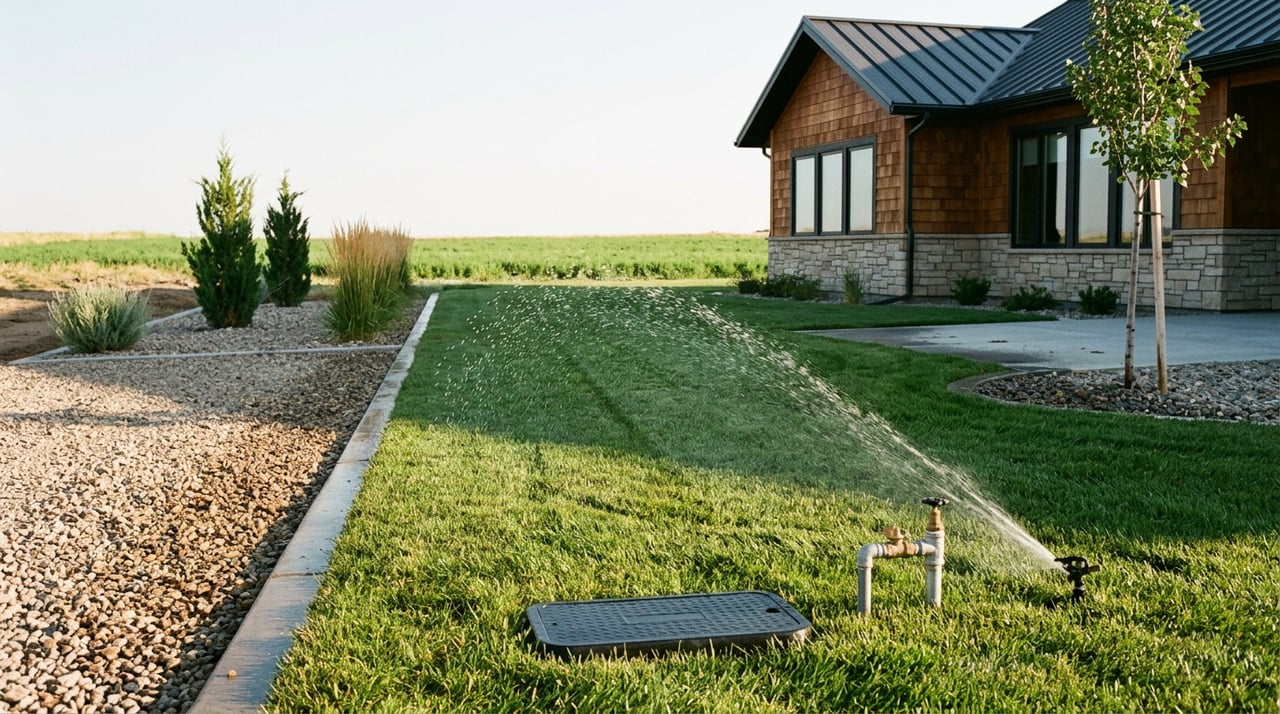
Walk the turnout or headgate that serves the property. Note the exact headgate or turnout number, visible condition, and any measuring device or markings that indicate flow. Confirm whether delivery is from a district canal or a private diversion. Ask for any parcel-level delivery records so you can see how much water typically arrives and when.
Follow the path from headgate across the property. Look at open ditches, buried pipe, siphons, and gated pipe. Note leaks, seepage, collapsed sections, or maintenance gaps. In HPID, owners are responsible for private conveyance on their land, and the district expects those facilities to be maintained to protect the system.
If irrigation uses a pump from a lateral or a groundwater well, gather pump specs, well logs, electrical service details, and maintenance records. If a seller claims an “irrigation well,” confirm that a valid DNRC water right or permit exists for that use. Pump capacity, lift, and power availability influence real operating costs.
Many parcels in the Huntley Project still use flood or furrow irrigation. Some owners add sprinklers or pivots, but pressurized conversions often require district approval. The HPID rules allow alternate systems with owner responsibility for costs and compliance. Clarify whether your intended upgrades are allowed and what approvals and easements are involved.
Canals, laterals, and drains come with recorded rights of way and O&M roads. Permanent structures, trees, and fences are often restricted within those corridors. Review the title report and the HPID rules to confirm widths and limitations, then mark those areas on your site plan before you design driveways, barns, or a pivot.
Start with the NRCS Web Soil Survey. Identify mapped soil units, infiltration, drainage class, and depth to any limiting layer. Use those maps to pick representative sampling spots. Probe holes or test pits help you check for shallow water tables, gravel layers, or restrictive horizons that affect irrigation.
Request a soil lab panel for texture, pH, electrical conductivity, and sodium adsorption ratio. Salinity or sodicity issues can limit crop choices and demand careful water management or reclamation. Montana State University explains how to diagnose and interpret results in its overview of salinity and sodicity in irrigated systems.
Ask for irrigation water lab results that include total dissolved solids, electrical conductivity, and key ions such as sodium, chloride, and bicarbonate. If quality is marginal and drainage is poor, you may need leaching, surface grading, or subsurface drains to maintain yields. On site, look for white salt crusts, wet spots that linger, or patches with poor plant vigor, then focus your testing in those zones.
Yellowstone County subdivision and health rules govern wells, septic systems, and some fire-safety infrastructure. Before you buy, pull the plat, any Certificates of Subdivision Approval, and staff reports tied to the property. The county’s subdivision regulations outline typical conditions for rural lots, including on-site wells and septic where public systems are not available. Review the Yellowstone County Subdivision Regulations for process and standards.
Many rural subdivisions record covenants that limit livestock numbers, additional dwellings, certain outbuildings, or commercial activity. Treat CC&Rs as binding. Get the full recorded document set early so you can confirm that your intended use fits the rules.
Ask the title company to flag recorded canal easements, O&M roads, and any district liens. Confirm the status of HPID O&M assessments and whether any charges or repairs follow the land to closing. District rules generally hold the landowner of record responsible for assessments.
Montana values agricultural land using productivity measures and formulas tied to net income and a statutory capitalization rate. Parcels of 160 acres or more are presumptively agricultural. Smaller parcels must meet specific use or income criteria to qualify. Irrigated land is assessed using productivity such as tons of hay per acre, and delivery costs are part of the income calculation. Review the Department of Revenue’s guidance on Agricultural Land classification and valuation and confirm status with the county assessor before you rely on a tax estimate.
Documents to request:
Questions to ask the seller or district:
Recommended specialists during escrow:
Watch for these potential deal-changers:
Negotiation ideas if one or more show up:
Ready to evaluate irrigated acreage near Shepherd with a clear plan? Reach out to talk through water rights, HPID service, and the practical steps that protect your investment. Call or message Carey Chapman to get started.
Stay up to date on the latest real estate trends.


Trust her to guide you through Billings real estate with care, insight, and reliable service. With local knowledge and a client-first approach, she ensures your journey is smooth, confident, and rewarding.